Interpret environments based on ichnology
Interpret and refine local depositional environments in core based on direct observations of presence and abundance of ichnogenera (trace fossils).
Enter information about ichnogenra using the appropriate filters and pop-up windows to view suggested interpretation results. These can be further refined using additional observations and facies models.
How does it work?
This portion of the dashboard is based on an expert system with thousands of relationships that links observations of ichnogenera within a sandstone, heterolithic, or mudstone lithology to possible Element complex (EC) interpretations.
The interpretation results can support the development of depositoinal conceptual models for the subsurface interval and inform static modeling decisions.
Practical Uses
Refine the range of possible local depositional environments (EC Categories) based on observed ichnogenera separated by sandstone, heterolithic and mudstone lithologies.
Explore alternative depositional scenarios that may have been overlooked in previous assessments and assess uncertainty.
Use interpretation results to guide predictions about potential parent depositional environments and possible architectures in unsampled areas beyond cored wells.
Skills required
- Identification of maximum transgressive and maximum regressive surfaces
- Identification of Element complex (EC) boundaries
- Identification of sandstone, heterolithic and mudstone lithology intervals within an Element complex (EC)
- Identification of ichnogenera and their abundance within a lithology and estimation of Bioturbation Indexes (BI) for intervals.
How to apply ichnogenera filters
Things you should know
Core intervals using this approach should only be interpreted after:
- Vertical Element complex (EC) boundaries have been defined.
- Each EC interval has been subdivided into sandstone, heterolothic and mudstone lithologies.
Lithologies are defined in the following manner:
- Sandstone - contains less than 10% mudstone strata.
- Mudstone - contains less than 10% sandstone strata
- Heterolithic - covers intervals that fall between the sandstone and mudstone definition criteria listed above. Both mudstone and sandstone strata should be greater than 10%.
It is recommended to use ichnology filters to refine results from manual selection, process-based, or physical structure-based filters, rather than relying on them for standalone interpretation.
Follow these steps:
- Open the Characterize Environments dashboard.
- In the filter sidebar, locate the Classify by identifying trace fossils filter section.
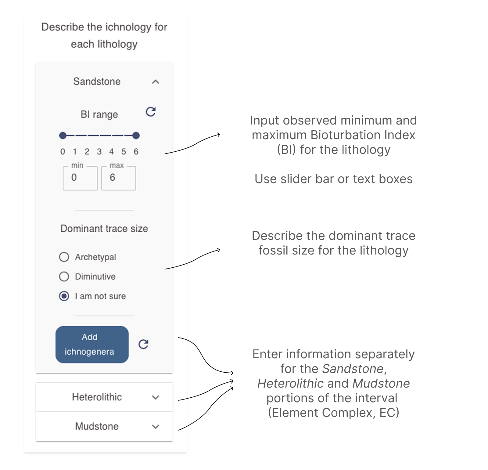
- For each separate lithology in the Element complex (EC) interval:
-
Open the accordion filter for the relevant lithology.
-
Enter the Bioturbation Index (BI) range for the interval using either the slider or the text boxes to specify the minimum and maximum values observed for that lithology.
-
Answer the question about Dominant trace size if possible.
-
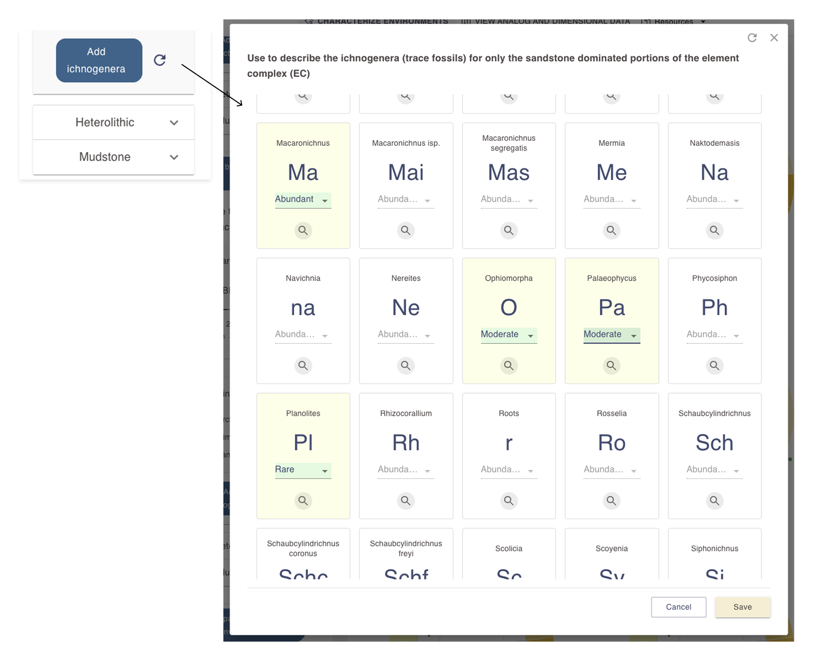
Click on the Add ichnogenera button to open a pop-up window where you will be able to enter information for individual trace fossils.
-
Select all ichnogenera present in the lithology and and optionally provide information about their abundance.
-
Use the hand lens buttons to view image examples of ichnogenera to help in identification.
-
Close the pop-up ichnogenera window and observe how the display area on the right has updated based on your inputs.
-
Combining physical structure filters with other filter types
When you apply filters from multiple sections in the Characterize Environments dashboard, the results displayed will reflect the categories common to all selected filters.
View and modify depositional environment results
The results display in the Characterize environments dashboard in shared by depositional environment interpretation filters. Open the View and modify environment category results page for more information the results area.